January 2025 · Los Angeles, California
The Palisades Fire ignited on January 7th, driven by Santa Ana wind gusts up to 100 mph, burning 23,448 acres and destroying 6,837 structures, claiming 12 lives across Pacific Palisades, Topanga, and Malibu. It became Los Angeles’ most destructive wildfire. Many of the affected properties were located in High or Very High Fire Hazard Severity Zones. The maps existed. The data was public.
Fire spreads faster than plans, assumptions, and insurance coverage.
Yet decisions – to build, buy, or invest – were made without fully considering what those maps already showed.
Environmental hazard data exists before disaster strikes, but it’s often checked too late.
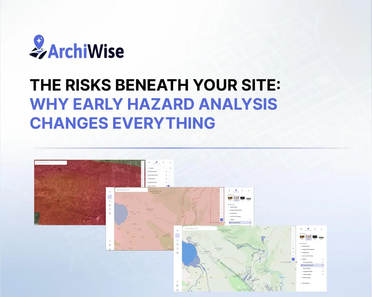
Today, information about flood zones, earthquake faults, seismic hazard, fire risk, and historical wildfires is widely available. The challenge isn’t availability, it’s bringing this information together early enough to influence decisions.
Tools like ArchiWise.ai help visualize these layers directly on a site, so risks can be understood before decisions are made, not after consequences appear.

Because in real projects, risk is rarely hidden – it’s simply overlooked.
Earthquake Risk: Why Ground Conditions Matter
Earthquakes are not limited to California. The 1994 Northridge earthquake (M 6.7) killed 57 people and damaged over 82,000 structures, many built to code. In 2024, a magnitude 4.8 earthquake in New York and New Jersey proved that seismic risk can exist in unexpected places.
What matters most is not just location but site conditions:
- Fault proximity can make a site unbuildable
- Soil conditions can cause liquefaction
- Ground shaking intensity varies even within small areas
Understanding both where faults are and how strong shaking can be is critical for safe design.
In ArchiWise, this is visible through:
- Earthquake Faults – USGS Quaternary fault lines showing known earthquake faults across the US, including fault name, slip rate, age, and sense of movement.

- Seismic Hazard – Expected ground shaking intensity (USGS NSHM), showing how strong shaking might be at a location, different from fault maps which show where faults are.

Flood Risk: A Growing Challenge in Site Selection
Flooding remains the most common and costly natural hazard in the U.S. When Hurricane Ida hit New York City in 2021, record rainfall overwhelmed infrastructure, leading to fatalities in areas not widely considered high-risk.
Flood risk directly affects:
- Building elevation requirements
- Foundation and drainage design
- Flood insurance obligations
- Long-term property value
Understanding flood exposure early allows teams to adjust design before costs escalate.
In ArchiWise, this is visible through:
- Flood Hazard Zones – FEMA flood zones from the National Flood Hazard Layer, showing areas at risk of flooding; SFHA zones (A, AE, V, VE) may require flood insurance.

Fire Risk: Beyond a Single Map
Recent disasters including the Camp Fire (2018), Maui wildfires (2023), and the Palisades Fire (2025) show how quickly wildfire risk becomes real-world impact.
Fire risk is often misunderstood because it requires two different perspectives:
- Regulatory risk (what is expected)
- Historical reality (what has already happened)
A site may not seem high-risk on paper but could still sit in an area that has burned before.
In ArchiWise, this is visible through:
- Fire Hazard Zones – Designated fire hazard severity zones (FHSZ), regulatory boundaries showing areas classified by fire risk (e.g., High, Moderate). Not the same as historical fire locations.
- Fire Footprints – Historical fire perimeters showing where wildfires have actually burned (name, year, acres, cause). Different from Fire Hazard Zones, which show designated risk areas.

Why Early Hazard Awareness Changes Everything
All of this data already exists flood maps, seismic models, fault lines, fire hazard zones, and wildfire history. But in many projects, it’s reviewed too late, after site selection or during design.
That timing leads to:
- Unexpected design changes
- Compliance challenges
- Increased costs and delays
Seeing these risks together, early in the process, allows better decisions and fewer surprises.
Platforms like ArchiWise bring these layers into one place, helping teams understand the full picture of a site before committing.
Final Thought
The difference isn’t access to data – it’s when you use it.
Check early. Decide smarter. Build with confidence.
ArchiWise helps developers, investors, architects, and brokers move beyond zoning theory and into parcel-level reality.
Whether evaluating land for housing, commercial projects, or infrastructure like data centers, ArchiWise provides decision-ready intelligence before time and capital are committed.
Explore how ArchiWise helps teams analyze real sites and make smarter development decisions.