SB-79 is not just another housing bill. It is a land-value shift.
Starting July 1, 2026, California will require cities in key transit counties to allow more height, more density, and more housing near qualifying transit stops than many local zoning codes currently permit. For developers, this represents a structural change in what transit-adjacent land can legally support.
In simple terms, transit proximity is becoming a legal development multiplier rather than just a planning consideration.
The Core Idea Behind SB-79
SB-79 establishes a minimum development envelope near transit. In practice, this means cities can no longer enforce zoning rules that fall below a state-defined baseline for height, density, and floor area ratio (FAR).
If a site qualifies under the law, state standards override restrictive local zoning constraints. This shifts how entitlement potential is evaluated, especially in urban transit corridors where local zoning has historically limited density.
Where SB-79 Applies
The law applies only in specific California counties with significant transit infrastructure, including Los Angeles, Orange, San Diego, San Francisco, Alameda, San Mateo, Santa Clara, and Sacramento.
Outside these counties, SB-79 has no impact. Inside them, however, distance to transit becomes a key driver in determining land value and development feasibility.
Why Distance to Transit Now Matters
At its core, SB-79 is a distance-based framework tied to qualifying transit stations. Sites within a quarter mile receive the highest development allowances, while those between a quarter and half mile receive moderate increases. Sites within 200 feet of station access points may receive additional uplifts.
The closer the site is to transit, the more development capacity the law unlocks.
What Developers Can Actually Build Under SB-79
SB-79 establishes a tiered, distance-based development framework that determines allowable building scale based on transit type and proximity to station access points.
In Tier 1 jurisdictions (heavy rail systems such as BART, Caltrain, and major LA Metro rail lines), SB-79 allows:
- Up to 9 stories within 200 feet of a station
- Up to 7 stories within 1/4 mile
- Up to 6 stories between 1/4 and 1/2 mile
In Tier 2 jurisdictions (light rail and high-frequency transit systems such as Muni Metro and LA Metro light rail lines), SB-79 allows:
- Up to 8 stories within 200 feet
- Up to 6 stories within 1/4 mile
- Up to 5 stories between 1/4 and 1/2 mile
These allowances are further supported by state-defined density and FAR ranges that scale with distance from transit, creating a structured increase in development potential closer to stations.
In practical terms, SB-79 introduces a graduated development envelope around transit, replacing flat zoning limits with a predictable, distance-based intensity system.
The Real Impact at Parcel Level
SB-79 operates at the parcel level, where even small differences in distance from a transit station can materially change development outcomes. A site that is just a few hundred feet closer to a station may shift into a higher entitlement tier, which directly impacts maximum building height, allowable density, overall project scale, and ultimately feasibility.
This makes transit proximity a primary driver of entitlement potential rather than a secondary planning variable. Feasibility is no longer fixed under a static zoning assumption. It is now directly tied to exact station distance and SB-79 tier classification.
What Qualifies Under SB-79
To qualify, a project generally must be located in an eligible county, be near qualifying transit, meet minimum size requirements, comply with use rules, and include affordability obligations.
SB-79 is therefore not automatic entitlement. It functions as a qualification framework that determines whether enhanced development rights apply to a site.
Affordability Requirement
Projects that utilize SB-79 benefits must include affordable housing contributions. These typically include 7 percent extremely low income, 10 percent very low income, or 13 percent lower income units.
This structure creates a tradeoff: increased density in exchange for affordability participation.
The Real Market Impact: SB-79 Is Changing What Actually Pencils
The biggest impact of SB-79 is not construction – it’s what suddenly becomes buildable. Transit-adjacent sites are being re-checked against new density and height allowances, and many are starting to look very different than they did under old zoning.
In simple terms, parcels that didn’t work before may now support real, viable projects, especially near strong transit stops where extra units and height change the entire scale of the deal.
This creates a gap between old assumptions and new reality. That gap is where early opportunities are forming.
What Developers Should Focus On Now
The most important shift is methodological. Developers must now prioritize transit proximity before zoning assumptions, measure distance precisely from parcel edge to station access points, and verify whether a site falls under Tier 1 or Tier 2 conditions.
Feasibility should be modeled twice: under existing zoning and under SB-79 allowances. In many cases, this comparison will determine whether a deal moves forward.
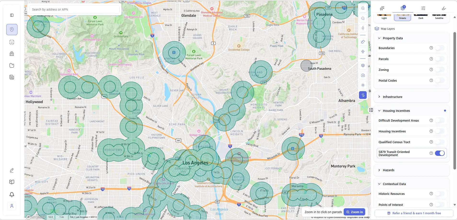
SB-79 Is Now Visible in ArchiWise
In ArchiWise, SB-79 is no longer something interpreted manually from policy documents. It is displayed as a mapped Housing Incentives layer that visualizes transit-oriented development eligibility directly on parcels.
SB-79 is translated into transit proximity zones, Tier 1 and Tier 2 classifications, parcel-level eligibility signals, and distance-based development logic. In simple terms, it becomes something you can see rather than calculate.

At the city scale, ArchiWise visualizes SB-79 across transit networks, showing where Tier 1 and Tier 2 eligibility zones apply and how development capacity changes along station corridors.
Parcel-Level SB-79 Decision View
When a parcel is selected and zoomed in, ArchiWise displays a real-time SB-79 eligibility panel based on station distance and tier classification.
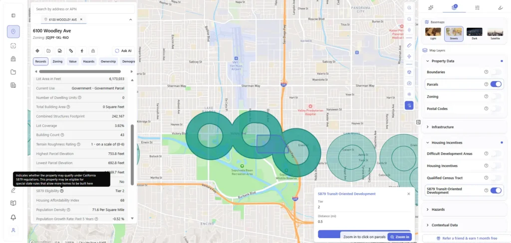
This view converts policy into a direct development signal by showing SB-79 eligibility status, tier classification, and exact distance to transit.
Final Takeaway
SB-79 does not affect every site, but where it applies, it meaningfully expands what land can become. For developers, the approach is straightforward: focus on transit proximity, verify eligibility, model the new build envelope, and act before pricing fully adjusts.
Under SB-79, the land hasn’t changed. The rules have.
Understanding SB-79 is one thing. Seeing where it applies is another.
Learn how ArchiWise makes that visible at the parcel level.