Most developers don’t make bad decisions.
They just don’t get to see enough options.
Because time runs out first.
You get a list of sites on Monday morning, and by the end of the week, you’ve seriously reviewed maybe four or five. Not because you’re slow, but because each site takes hours to understand properly.
Zoning is in one system, hazards in another, infrastructure somewhere else, and demographics buried in yet another tool. Before you can think, you have to search. Before you can decide, you have to assemble everything manually.
What if all of this was already in one place?

That’s where the time disappears.
And the real problem is that it was never about judgment. Developers are already good at making decisions. The bottleneck has always been everything that comes before it, the repetitive, fragmented work of gathering data across disconnected systems, rebuilding context for every single parcel, again and again.
What changes when everything is already there
Now imagine something different.
You open the map and see many sites at once, all ready for review in a single view. Instead of switching between tools or checking parcels one by one, everything starts in one place.

At this point, you’re not just reviewing listed opportunities, you’re working with off-market parcels, turning the map into a true deal sourcing tool, not just an analysis tool.
You begin with a simple filter, lot area and year built, to narrow down sites that better match your project requirements.

The map updates instantly, showing the number of sites and making the next step easier.
Next, you add the last sale price and current use to align the shortlist with your acquisition range.

Now you’re not just filtering by site, you’re filtering by fit.
Then you bring in demographics, including income levels, poverty rate, age distribution, and education levels, to understand whether the market actually fits your product.

Each step brings the list closer to what actually works.
At this point, you’re down to a small set of strong candidates.
From there, you can switch to a list view to see those sites clearly, with addresses and key details ready for the next step.

What used to require multiple tools and hours of back-and-forth now happens in a single, connected flow, where each step builds directly on the last.
Start with the first filter – and move fast
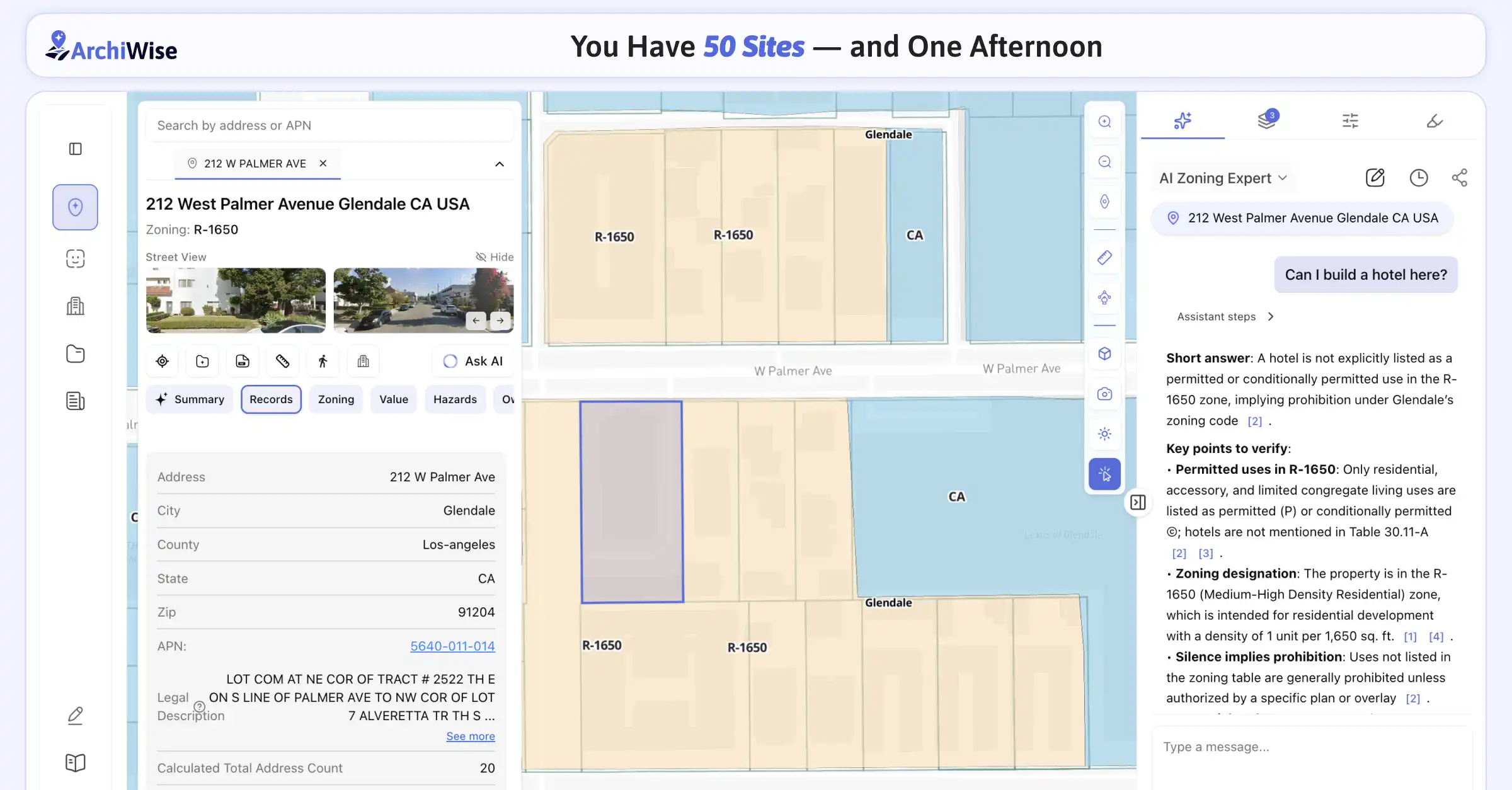
Every site begins with the same question: can you even build what you want here?
In theory, this should take seconds. In practice, it often takes an hour or more, buried in zoning PDFs, planning websites, and inconsistent municipal systems.
With ArchiWise, zoning becomes visual. Constraints are immediately clear. Permitted uses and density are visible on the map itself. A site that doesn’t work gets eliminated instantly, without wasting time on analysis that goes nowhere.
And sometimes, the upside matters just as much as the constraint. For example, if a parcel falls within an SB-79 transit-oriented area, it may allow higher density or faster approvals, turning an average site into a much stronger opportunity.
Across fifty sites, that level of clarity saves days of work.
Then: understand the land in seconds
Once zoning is clear, the next step is understanding the land itself.
Exact parcel boundaries matter more than people think. You need to know precisely what you’re buying, whether the lot is usable as-is, and whether adjacent parcels could be combined into something larger.
Instead of guessing from satellite images, you see it directly, clean boundaries, shapes, and relationships that reveal both constraints and opportunities immediately.
Market fit, without the deep dive
Zoning tells you what’s possible, but the market tells you what’s viable.
At this stage, you don’t need a full report, you need a fast, confident signal. Is this a renter-heavy area or ownership-driven? Are incomes strong enough to support your product? Is demand growing or already stretched?
ArchiWise brings those answers directly into the same view, so you can understand fit without breaking your workflow. You either lean in or move on.
Ask anything. Get answers instantly.
Sometimes you don’t want to scan layers. You just want a direct answer.
“Can I build a hotel here?”
“What’s the max density on this site?”
“Are there any risks I should know about?”
ArchiWise AI chat gives you clear answers instantly, grounded in the data on the map. It interprets zoning rules, infrastructure, hazard exposure, and also pulls from city zoning codes, planning documents, bills, and specific development plans, all in context.
No digging through zoning codes. No switching between tools. No guesswork.

The deal-killers you can’t afford to miss
Some problems don’t show up early.
That’s what makes them dangerous.
Sewer access too far away. Pipelines crossing the site. Limited electrical capacity. Or environmental and natural risks like flood hazard, fire hazard, fire footprints, earthquake faults, and seismic hazard that can heavily impact feasibility, insurance, and long-term viability.

These aren’t minor issues, they kill deals, often late in the process.
ArchiWise brings them forward so they can be screened immediately, before time and effort are invested.
Reality check: is the market actually moving?
Good-looking data isn’t enough.
You need proof of activity, projects under construction, active listings, leasing velocity.
This is where assumptions get confirmed or challenged. And seeing it early changes decisions completely.
What one afternoon actually looks like
It starts wide, with 50 sites on the map.
Then, step by step, the list becomes clearer. Filters remove what doesn’t fit. Data adds context. Risks are identified early. Opportunities like transit-oriented zoning stand out.
By the end of the process, you’re not looking at possibilities anymore-you’re looking at decisions.
From fifty sites to a focused shortlist, in a single afternoon.
The real advantage isn’t speed
It’s visibility.
Teams that win don’t necessarily make better guesses. They simply see more, more sites, more context, more opportunities, and they move before others do.
This doesn’t replace judgment
It clears the path to it.
You still decide what to build, where to invest, and what feels right. That part never changes.
What changes is how fast you get there.
Learn More
ArchiWise helps developers, investors, architects, and brokers move beyond zoning theory and into parcel-level reality.
Whether evaluating land for housing, commercial projects, or infrastructure like data centers, ArchiWise provides decision-ready intelligence before time and capital are committed.
Explore how ArchiWise helps teams analyze real sites and make smarter development decisions.